
Cartographical
—drawing a great blank grid, labelling its axes—
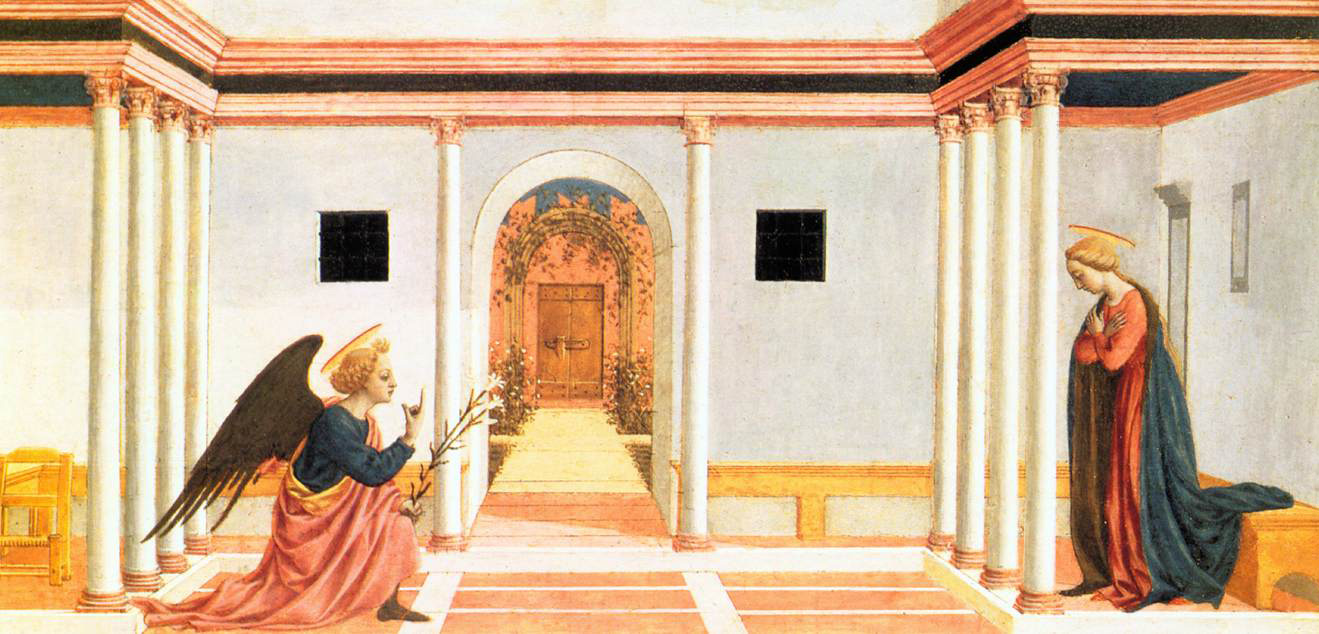
– Annunciation
Domenico Veneziano
How would you go about mapping the Ideal City, diaphanous, as it is, with ideas? Ideas, and by extension Ideal Cities, have their location after all, their interrelation. You can get lost in them. Why, therefore, not map them?
And perhaps after all there are ways. Perhaps you would map the Ideal City in the same loose way that you would map any unknown land. We know what that feels like. Someone tells you with a wave of arms that the sea lies beyond the mountains to the west, that you should cross a river, a desert, some broken hills; and so off you go, day after day, groping across the landscape like an ant loosed from its hill, casting uneasily in your head for signs (are those the mountains I see now? Was that the river they spoke of? Are these lands sufficiently dry for a desert?) which you can correlate with the vague story of your journey told you, like a child, for your comfort before you left.
In time, if you make enough journeys, do enough trade, system will creep in: yards and miles, compass points, elevations. The land joins up, slowly meshes under our feet. And we can cast off those infant tales.
And so in mapping the Ideal City, our sublime terra incognita, our landscape of ideas, I would begin by drawing a great blank grid and labelling its axes; and then I would roll it up and place it under my arm, and I would set out on foot.
—terra incognita—
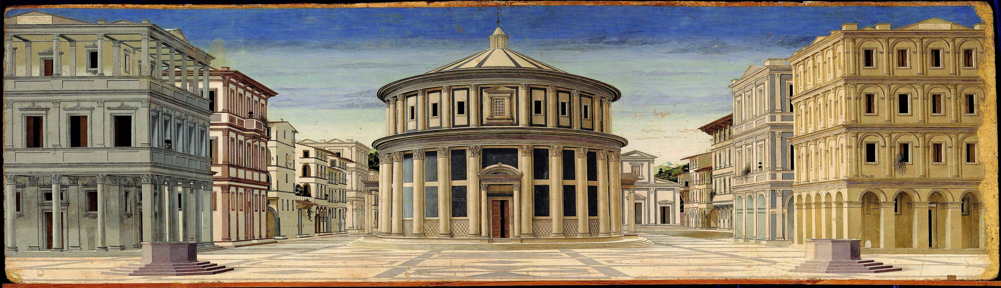
– Ideal City
Urbino
![]()
Italo Calvino’s invisible cities inhabit undifferentiated space. The only thing in the landscape is the city, and the camel trains or solitary ships which do not so much connect them as oscillate imperceptibly, if doggedly, between them. The cities stand in no particular relation to one another. They are discrete psychic objects, loosely corralled (by Calvino) into abstract sets.
Each of the cities bears the name of a woman. Olinda, Raissa, Marozia, Teodora, Berenice, Melania, Adelma, Eusapia, Argia, Laudomia...
Kublai Khan, sitting listening to Marco Polo (or watching him1), forced to consider the troubling plenitude and multiplicity of his domain, does not really need to know where each city actually is, only the nature of its quiddity. We understand that Marco Polo himself is an adept of this land’s geography (he is employed in the Khan’s administration of his empire), but does not need to supply it in any formal way to Kublai Khan. Or rather, the formal lineaments of the geography of the Empire—provinces, rivers, mountains—are irrelevant to the relational nature of Marco’s own geographical shorthand (three days journey beyond x you arrive at y).
—troubling plenitude—
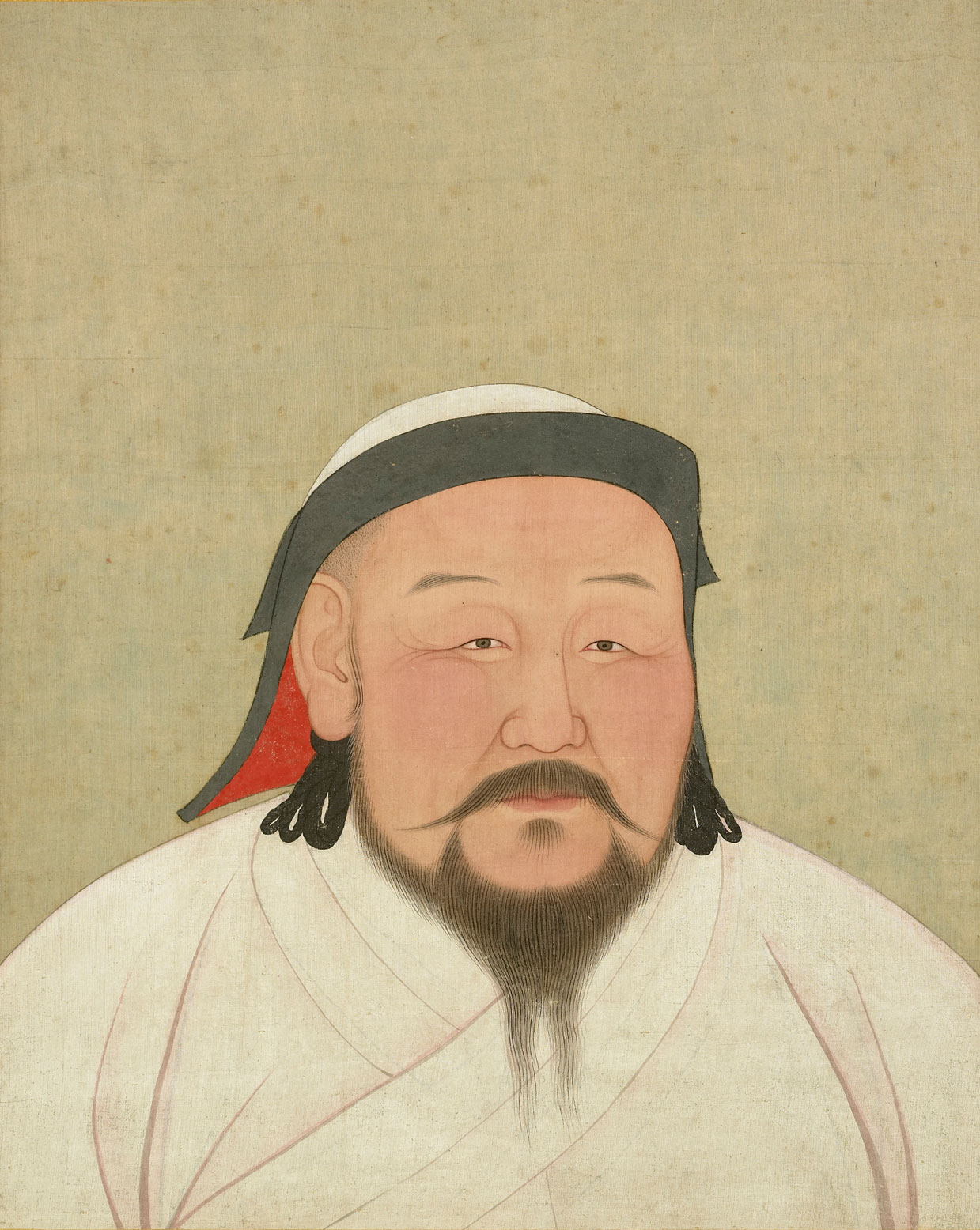
– Kublai Khan as he would have appeared in around 1260
Araniko (c.1294)
The Khan might also have his maps, his cartographers. Perhaps, like the College of Cartographers in Borges’s story Of Exactitude in Science, whose map of the Empire grows so large that to unfold it requires first a whole province, then the Empire itself, their ambitions are aggrandising: their form of enquiry will dissolve, in time, into the object of knowledge.
Perhaps the Khan knows this—he is an Emperor, after all—but knows also that the maps his cartographers produce are political objects, expressions of power, a form of spatial census.
Marco provides a different class of data. Empires change, after all, necessarily faster than the maps of them.
Marco relates the experience of phenomena—ghostly tales of places shimmering out on the far margins; places emerging from the desert and subsiding into the sea; a spectral landscape that comes into being as he passes through it and disappears as he moves on. If he has a map of any of this it is carried in his head, in the form of a traveller’s tale.
![]()
As William Ewart Gladstone recognized from his reading of Homer, much of our mental mapping of the world is fanciful; all of it is provisional.
I can recall for example the brow-furrowing effort I had to make in order to understand just exactly what and where Devon was when, aged five, one of my classmates told us her family was moving ‘down’ there. Assisted perhaps by the ‘clarifications’ of the teacher, and the gravitational pull of ‘Heaven’ which, this being a Catholic primary school, was much discussed in relation to the death of pets, grandparents, and crucified gods, I can still summon to mind the image I then formed of it, a dislocated demi-paradise of cream teas and sandy beaches floating in some lower sky, a mezzanine to the main body of the world.
I do not wish to draw too-precise parallels between my own infant geography and that of the nascent Greeks, but it seems natural to wonder how an imaginative and intelligent citizen of the Bronze Age—Homer, for instance—might have mentally configured the world in which he lived and of which, like the citizens of Norbiton, he sang, given that he had neither a map of any part of that world nor any useful idea of map in general.
Gladstone certainly found it natural, so to wonder. And he believed that his own scholarship could supply Homer’s deficiencies—that Homer’s mental image of the world could be not only imagined, but plotted. And thus in 1858, between stints as Chancellor of the Exchequer in Palmerston’s governments, he found time to publish his three-volume Studies on Homer and the Homeric Age, in which he produced an ingenious and fairly presumptuous map of the Homeric world.
There had been many prior attempts to pin the geography of The Odyssey (and, to a lesser extent, The Iliad) to the actual geography of the Mediterranean. But Gladstone, while accepting the historical and geographical veracity of the Homeric tales, saw that Homer’s geographical knowledge came in two distinct flavours, which he labelled Inner and Outer, and that the differential between them precluded any precise real-world correspondences, at least where the Outer was concerned.
The Inner Geography was the world as known to the Greeks through personal exploration, and comprised the Aegean and mainland Greece as far south as Crete and as far east as the littoral of Asia Minor; but not at this point as far West as Magna Grecia (the first Greek colonies in Southern Italy were founded in the eighth century, but Gladstone was assuming a much earlier date for the composition of the Homeric corpus – perhaps the fourteenth century). It corresponded to the geography attested to in The Iliad (and especially in the Catalogue of Ships) and the parts of The Odyssey centred on Ithaca.
The Outer Geography was the world known only through the dubious conflicting second-hand tales of Phoenician sailors—rumours of monsters and clashing rocks, islands of cyclopes and sorcerers—and it corresponded to most of the rest of The Odyssey.
Gladstone’s contention was that for Homer, the Outer Geography is not qualitatively different from the Inner; it lies on a spectrum of attested fact, and if it is merely provisional in nature, then this is true of all geographical knowledge, historically considered. Homer’s geography is therefore neither pure fancy nor proper fact; and if it cannot be tied to the topographical realities of the Mediterranean as we know them, nevertheless an abstractly configured mental map, tethered at various points to a known world, could be reconstructed, as follows:
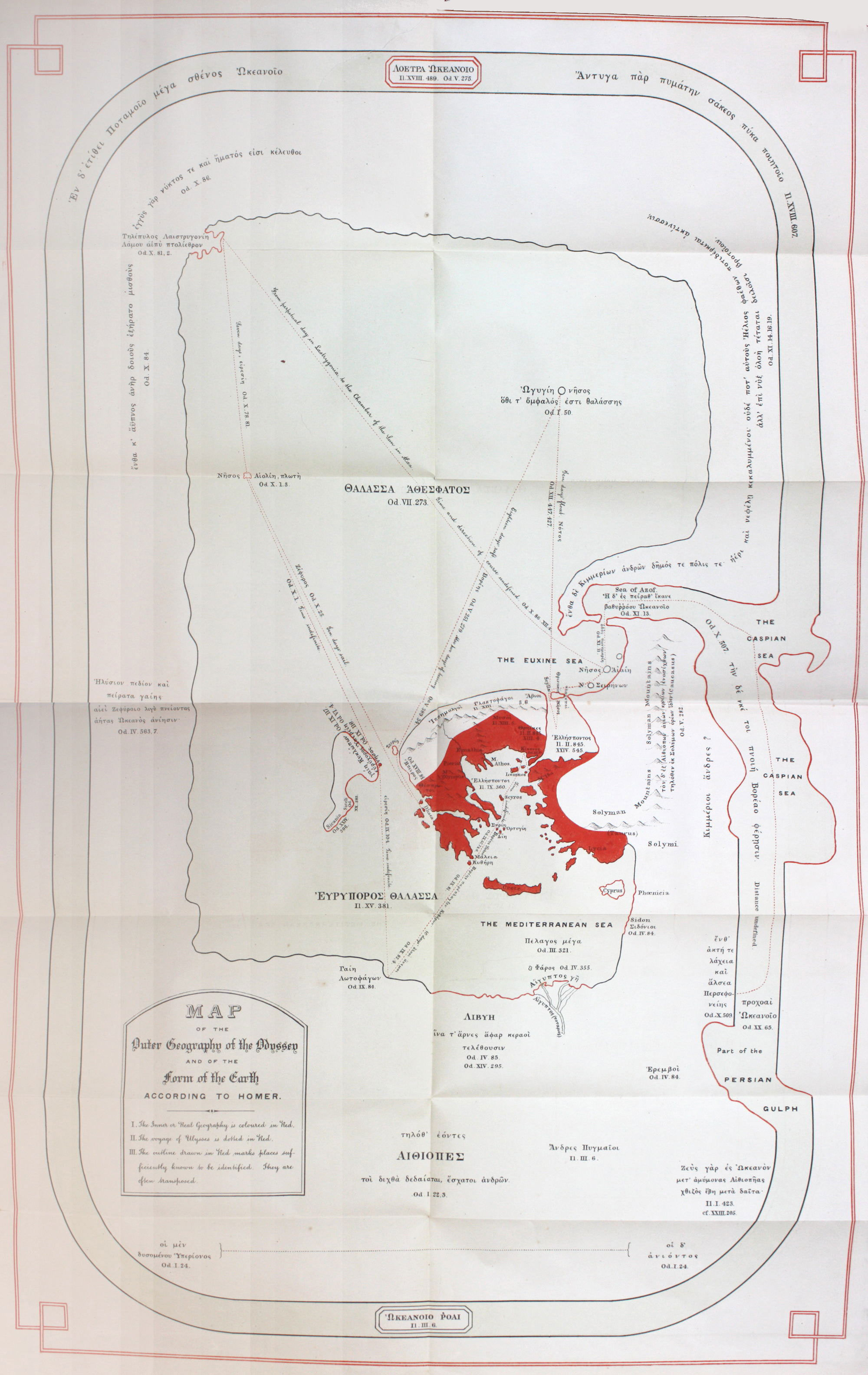
—tethered at various points to the known world—
– Map of the Outer Geography of the Odyssey and of the Form of the Earth According to Homer
Studies on Homer and the Homeric Age, W.E. Gladstone
The world is represented as an oval shield, circumbound by the World Ocean. Greece—the red mass at the centre—and the Nile Delta are correctly situated; Italy can be made out to the west of Greece, and the coastline of ‘Phoenicia’ to the east; the Adriatic gives access to a vast sea stretching to the north of Thrace, which allows adequate play for Odysseus’s wanderings as derived from the wind directions and travel time in days noted in The Odyssey. Gladstone has helpfully annotated it in a muddle of Greek and English.
Needless to say, none of Gladstone’s speculations regarding Homer’s geographical understanding have any current validity (and they were in fact almost universally rejected at the time of publication), partly because of his erroneous assumptions regarding the manner of oral composition and transmission of the text, and partly because he had in his own head a hyper-rationalist version of cognitive psychology according to which it was not possible to ‘know’ geography without having first studied maps.
But it is worth recalling that our own mental Atlases are not limited by the procrustean projections of modern cartography. A city on a map—New York, Milan, Norbiton—has to be triangulated with our experience of it, the tales we have heard tell of it. It will be provisional, not because places change, but because our understanding of them does. Gladstone’s bizarre reconfiguration of the actual world on Homer’s behalf (the work, it should be noted, of a future Prime Minister with a lurid and extensive outer geography of his own, who would attempt to use the British fleet to locate Atlantis in the South Atlantic) was if nothing else sensitive to the blind and groping engagement of the imagination with the empirically real world—which is, I loosely suppose, what Epic and other compendious, Nobitonian literatures amount to.
![]()
"Whatever materials Homer may have obtained to assist him, we must consider as so many atoms; I speak of course, as to all that lay beyond the narrow sphere of his Greek knowledge and experience. He had no adequate means of placing the different parts of the accounts which reached him in their true geographical relations to one another. The outer world was for him broken up into fragments, and these fragments were rearranged at his pleasure, with the aid of such lights only, as his limited physical knowledge could afford him...
"…an intense earnestness accompanies Homer every where, even through his wild and noble romance. Cooped up as he was within a narrow and local circle—for such it was, though it was for so many centuries the centre of the whole greatness of the world—here is his effort to pass the horizon ‘by strength of thought;’ to pierce the mist; to shape the dim, confused, and conflicting reports he could pick up, according to the best of his knowledge and belief, into land and sea; to people its habitable spots with the scanty material he could command, every where enlarged, made good, and adorned out of the wealth of his vigorous imagination; and to form, by effort of the brain, for the first time as far as we know in the history of our race, an idea of a certain configuration for the surface of the Earth."
W.E. Gladstone Studies on Homer and the Homeric Age, Vol. 3 p.251-2
![]()
Clarke is intent on mapping Norbiton: Ideal City.
He is not very clear or articulate about what exactly he intends, but broadly it involves creating a chorographical map from the top of Madingley Tower (where he lives) – a spot which he now calls the Isolarium.
The map will be made of photographs, from what I can gather, taken with frog-eyed wide-angle lens and telephoto lenses, superimposed and stitched together.
He has ambitions, he intimates, to create a clickable, navigable map of Early Modern Norbiton, as he chooses to call the Ideal City. This bulbous and distorted panorama will be hyperlinked to, I don’t know what, slurries of anecdote, aetiologies. He will achieve all this with the help of Emmet Lloyd, who has access to programming resources.
Clarke intends to call it, with glorious abandon, The Atlas of Norbiton.
Interesting though the idea doubtless is, I cannot help but wonder if it is not set up in rivalry to the Anatomy of Norbiton which, I now realise with no little smugness, is swelling to Borgesian dimensions of completeness.
My smugness is alloyed, however, with the knowledge that I will perhaps at that point need to provide a map of the Anatomy itself. And, unlike Gladstone, I have no idea how to do that.
![]()
In Star Trek: Voyager, the character known as Seven of Nine is released from the Borg collective, the hive mind, and is forced to seek ‘perfection’ by other means.
She spends most of her time in the Astrometrics Laboratory, the seat of Stellar Cartography, where she combines various Borg technologies with Starfleet Yankee know-how in the pursuit of improved navigational charts.
The Borg, it transpires, impose a series of matrices on space through which they then enumerate spatial grids, on which grids they can map any object you care to mention: galactic clusters, nebulae, star systems, planets, species, rocks.
A navigational chart presumes no route. All eventualities are covered with equal attention. Voyager is torn between one route of paramount interest—the route home—and the infinity of alternative routes encapsulated in the drive to explore. Exploration is one way of making maps—you jot down what you see as you go, like leaving breadcrumbs. But having the grid prepared so that you can pin down the clustered objects as you encounter them is a form of ersatz sanity. No object that comes into sensor range as you bolt around space cannot be pinned in relation to every other known object, even if you know that some of those objects have orbits, are wormholes, singularities, inexplicable entities.
Did I say ersatz sanity? No, this is a model of the real thing.
![]()
If the Borg did annunciations, they would be done in linear perspective.

—resistance is futile—
– San Lorenzo Annunciation
Filippo Lippi
Linear Perspective, properly understood, is a fully-worked out and mathematically coherent (if necessarily schematic) description of space, not a mere accumulation of foreshortened objects.
A discovery of the quattrocento, its single great innovation was a series of techniques for calculating the ordered recession of transversals into the picture plane—so a tiled floor, for example, or a coffered ceiling looked right because it was right. In this way the recession of the transversals corresponded to the convergence of the orthogonals, and the box, so to speak, was closed.
Objects could now be located and set down in (imagined) space rather than daubed over the front of a bit of wood or the wall of a chapel. The picture plane erases itself, becomes a window on another world, a world which is mappable because it started its intellectual life as a series of coordinates.
In Erwin Panofsky’s view, we are now looking, for the first time in the history of art, at a space that is homogenous, isotropic, infinite. Some would go further. Infinity itself, such a horror even to Kepler, to Pascal, was born, it has been argued, of this fundamentally technical leap of understanding2.
![]()
The city, from the quattrocento, is a unified space; a perspectival space. It is no longer represented or experienced as a medieval cluster of objects—castle, cathedral, tower jumbled within the walls—but as a homogenous, infinite, isotropic space in which (Panofsky again) the bodies inhabiting that space do not have any greater weight or so to speak density than the space between them. The city is not, as in Calvino, something squatting in the desert, something you arrive at; it is an intelligible and relational, open and geometric sanity, through which you can move.
In quattrocento art the miraculous events of biblical and classical history take place, for the most part, in cities, have a civic backdrop. Linear perspective craves straight lines and the new architecture provides them: colonnades, entablatures, tiled and paved floors, coffered ceilings.
Unlike the wilderness, the city is a space that can be managed. Handled. Done in perspective. It is separated into distinct blocks and squares, named, numbered perhaps. A mappable space.
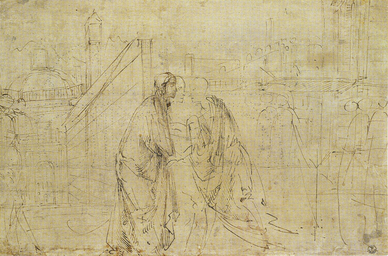
—handled—
– Study for the Visitation
Domenico Ghirlandaio
And as with the city, so too with domestic space. Rooms, staircases, bed chambers can be mapped on a grid: are a grid, in a manner of speaking.

—mapped on a grid—
– study for the Birth of the Virgin
Domenico Ghirlandaio
What this should mean to my own experience of space, as I leave my room and walk the placid streets of Norbiton, is something I puzzle over.
![]()
J.V. Field notes that virtually no pictures in the quattrocento were in fact done fully, which is to say remorselessly, in linear perspective3. What he means is that, in the first place its take up was sporadic, even if it appealed to the most modern tastes; and then even when a coherent spatial scheme is attempted, and carried off, there will be accommodations to pictorial taste, perhaps to iconographic convention: a good painter will not simply do the math.
Linear perspective does not solve problems. It creates them. And the problems that it creates—like the technical, aesthetic and conceptual problems of providing a projection of the globe in two dimensions—are insoluble. If you designate a position from which a painting should be (ideally) viewed, you have to rethink everything. If a painting is going to be viewed from below, how do you paint a crowd such that the rear ranks are not obliterated by the front? The serried ranks of the duecento, trecento, are now a jostling melee; heads crane, peer, catch a glimpse. This is not how heaven was supposed to be. It is not a procession, it is a scrum.
And what about narrative? If the pictorial space is coherent, designed to provide a metonym of the space we are accustomed to associate with our subjective experience of 'reality', then how do you tell the whole story of, say, the tribute money without showing Peter three times in the same space?
The great paintings of the quattrocento did not ‘do’ Linear perspective, so much as wrestle with its implications.
![]()
Witness, for example, the following:
—wrestle with its implications—
– Bartolini Tondo
Filippo Lippi
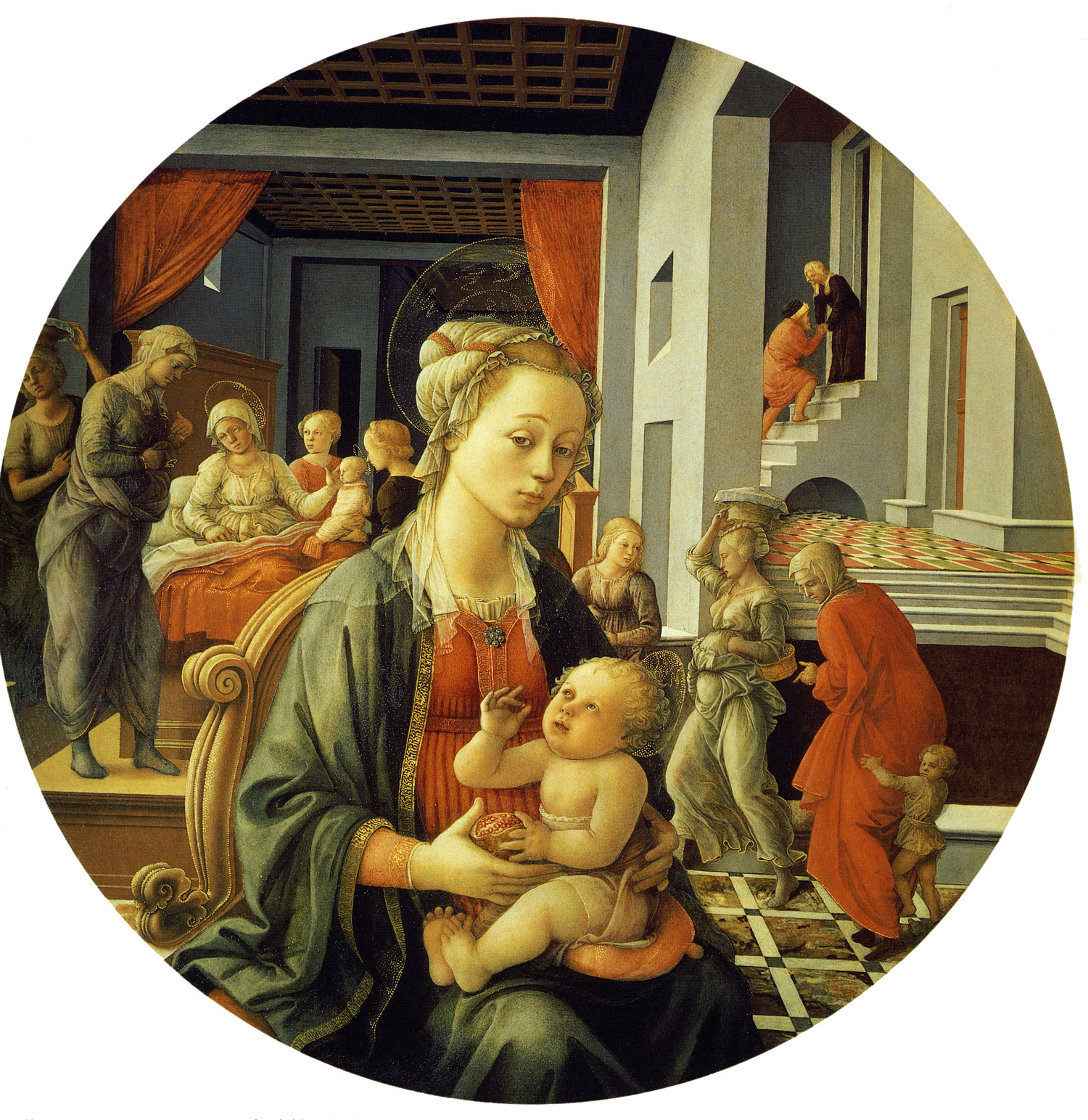
This, the Bartolini tondo, was painted by Filippo Lippi in about 1452. The tondo was typically a decorative domestic item, and like the cassone or marriage chest it was associated with a specific domestic ritual—in this case the birth of a child. They are known, in fact, as deschi da parto, or birth trays.
The Bartolini tondo depicts the Madonna and Child against a bi-partite narrative scheme illustrating moments of the Virgin's pre-history, so to speak: on the left is her birth and on the right the meeting of Anne and Joachim in which moment she was, according to legend, immaculately conceived.
This collapsing of iconic and narrative pictorial conventions is catastrophically odd. What exactly is being mapped back there? The spaces are coherently handled, but precarious. The little boy seems to be sliding off the floor: he is clinging on to the skirts of his mother not for comfort but for dear life; the serving woman in the centre-right is pinned and observed (from behind?) like a butterfly; Anne is hoiking Joachim up the steps at the back as though the pair are roped together on the Eiger.
The windows and doors interpenetrate the space, seem to be constructed in divergent planes. Do all those floor planes really converge? It's possible (although just why the floor of the bedroom and the pavement of the city should converge is anyone's guess) but the foot of the bed (near the critical centre of the composition), isn’t that just wrong? The honeycomb ceiling certainly vanishes, into some pitchblack wormhole of memory; the bedroom might be on the extreme outer edge of a vast wheel of an Ideal Fortress-Palace.
Understood as a map of space, there is nothing sane, rational, coherent about this. But sitting at the front, quite comfortable, is the Virgin, dandling her pomegranate child. Everything (behind her, below her, in her lap) is a peculiar dream to which she gives no special credence. But then we know from our (skewy, apocryphal) Biblical history that the predicaments of the various individuals in the hyper-imagined spaces beyond are her own predicaments; they are generated or pictorially sustained by the multi-dimensional tangle of her hair and hair piece and the halo spinning at near-light speeds; she is, despite her apparent poise and lightness, a swirling gravitational mass, a spatial sorceress, a Circe.
In other words, if we try to understand this picture as a conception unified by known principles of orderly recession it is deeply perplexing; if instead we understand it as organised around the considerable asymmetrical pictorial weight of the Virgin—if we lean, in other words, towards an iconic reading of it as a devotional object—it is, I hardly know, excusably beautiful.
In its asymmetrical weight it is, in other words, closer to this:
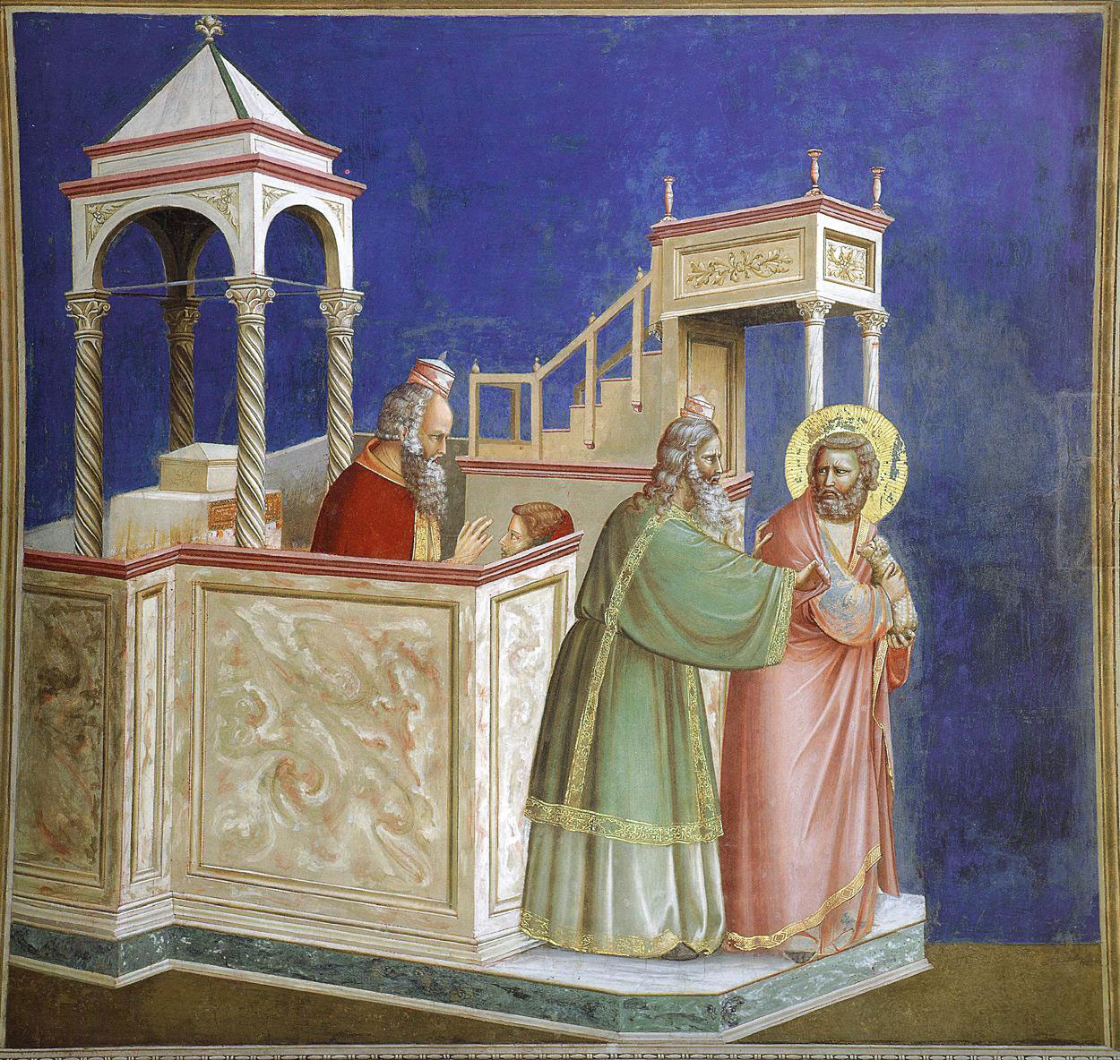
—space-time continuum—
– Joachim Ejected from the Temple
Giotto
... where a deeply puzzled Joachim seems about to be ejected, not from a temple, but from a space-time continuum, than to this:
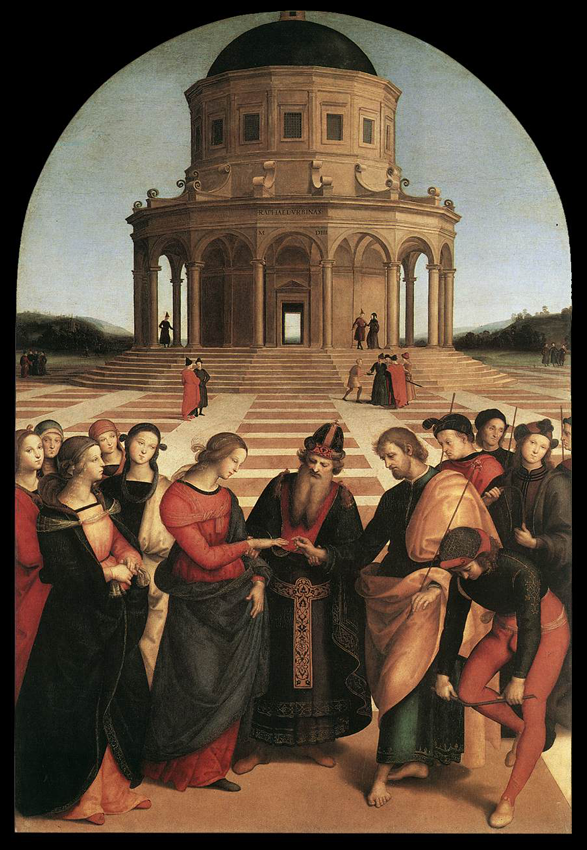
—everyone knows precisely—
– Sposalizio
Raphael
... where everyone knows precisely where he or she stands.
![]()
Lippi’s composition is determined by the shape of the field. Linear perspective on a circle was always going to be a challenge.
The picture hangs in the Palazzo Pitti in Florence, and I cannot remember, and cannot tell from reproductions, if the panel on which it is painted is given to convexity or concavity or neither. My perceptual apparatus, the more I stare, is thrown into crises of uncertainty. And then, this is a large object—1.38 metres across. Perhaps, when you stand in front of it, it would all make sense. There is no way of knowing, and I don't remember.
I am locked now in Norbiton. There will be no more standing in front of it.
Perhaps for our purposes the best map after all is the Isolarion; as though Clarke up there on Madingley Tower with his monster cameras could spy out the places on my map for me; Venice, let’s say, and Florence; and Urbino and Arezzo. When you are young you look at maps and see the names of places dotted over them; and then, as you live out your life, you visit some of them, live in others, have friends here, or there, fall in love in this one, or that—a random set taking on different valencies, different weights. Some—perhaps Tokyo, or Sydney, or Jerusalem—will be forever known to me as a medieval composite: bullet trains, neon signs, opera houses, harbour bridges, wailing walls and temple mounts; others will be known and frequented mental spaces, albeit no less, perhaps a degree more, distorted.
This woman in the Bartolini tondo is a virgin with a child. Perhaps no wonder it is strange. A desco da parto full of virginal mother and immaculate conceptions. I do not know the circumstances under which such a painting would have been presented to a Florentine mother but I suppose it is unlikely that they would have nailed it to the wall as she lay there in a far corner of a great stone palace, pummelled with childbirth, laden with sweat and blood and a swaddled infant, surrounded by the men of the House congratulating themselves on the birth of an heir and conspiratorial womenfolk to whose conspiracy she is not party but temporarily subject; it could not have taken place like that—the presentation—unless the household were undergoing a narrative collapse analogous to that occurring the painting.
However, I find myself wondering what she must have made of it, this luxury object in a world of few luxuries. Would it have helped her to locate herself on her personal map, insofar as that map overlapped with the rituals and roles of her people? Would she have understood, in the sense of submitted to, what it meant?
Or would she have (mentally, emotionally) stood against it? Here was a picture, after all, of her child's projected suffering. Somewhere, out across the terra incognita of the future, with its spectral mountains and salt lakes, its sorceresses and monsters, her child was suffering, lost, alone. Crucified, if she was unlucky. And here was a map of it all, illegible, broken, zany, misdirected, and annotated to destruction by a distant future Englishman, an unimaginable Gladstone of Norbiton, lost himself and muttering on some far margin of the Outer Geography of the world.